


This article was published on Southern Science. Click here to see the article on Southern Science.
RIVER, INTERRUPTED
Study could restore fish migration path from Gulf to Cahaba River
by Sydney Cromwell
The 318-mile-long Alabama River is a highway for fish that migrate between the Gulf of Mexico and inland waterways, including the Coosa and Cahaba rivers. But that highway is interrupted by several aquatic “roadblocks” — dams that make migration nearly impossible.
“Our river systems have been altered so much by dams over the decades, and initially we may not have recognized the ecological harms we were doing, putting these giant obstacles in the river, stopping fish from going where they naturally go to spawn. … It just disrupts the whole system,” Alabama Rivers Alliance Executive Director Cindy Lowry said.
Two of those disruption points — Claiborne Dam and Millers Ferry Dam — are the focus of a study by the U.S. Army Corps of Engineers Mobile District and the Nature Conservancy of Alabama, to see if migration routes can be reconnected around the dams.
“It could be one of the most significant ecological restoration projects to happen, certainly in my lifetime, in our nation,” Lowry said.
FACING EXTINCTION
Jason Throneberry, the Nature Conservancy’s director of freshwater programs, said about 10 to 15 fish species, some of them threatened or endangered, migrate up and down the Alabama River. These include American eels, paddlefish, sturgeon, alligator gars, mullet and Alabama shad.
“We haven’t yet lost the Gulf sturgeon, we haven’t yet lost the Alabama sturgeon, … but we have a lot of other species that are right there on the very brink of extinction,” said Alabama Audubon executive director and former Birmingham-Southern College biology professor Scot Duncan.
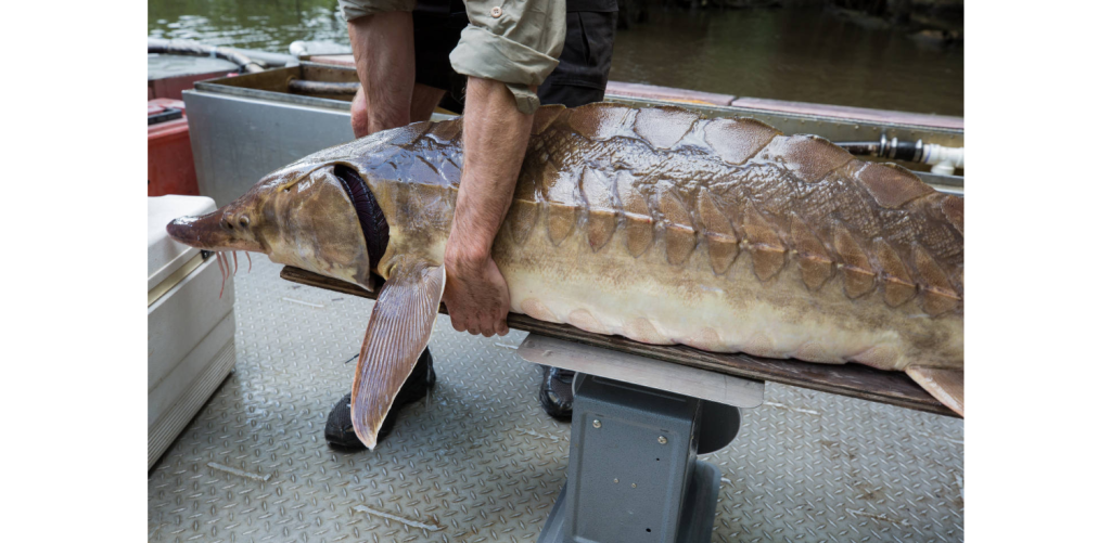
“The Alabama sturgeon is the rarest fish in Alabama, and maybe extinct. No one’s seen one in years,” said Rusty Wright, an associate professor and extension specialist at Auburn University School of Fisheries, Aquaculture and Aquatic Sciences.
Dams have caused problems with far more than just migration routes. Changes to the water’s speed, depth, temperature and oxygen level that result from damming can sometimes make a river inhospitable to the native species that once called it home.
This includes creatures like snails or mussels, which depends on passing fish for its own reproductive cycle. The mussel larvae live as temporary parasites on these host fish before they grow into adults. Alabama has some of the highest levels of diversity in these species in the nation.
In the Cahaba River, Throneberry said, there are populations of large, adult elephant-ear mussels, but there are almost no young mussels to be found because they aren’t able to survive without hosts.
“That whole species, at least in the Cahaba River, is going to blink out” without fish migration, he said.
“Reconnecting one of the most diverse rivers in the world to the Gulf of Mexico for the sake of fish passage would be fantastic.”
Jason Throneberry, Nature Conservancy of Alabama
The Center for Biological Diversity has called the damming of the Coosa River the “greatest modern extinction event in North America” due to the loss of 36 species.
“It really does change the whole system, not just those individual populations, when you’re able to move them up [the river],” Wright said.
Along with Dennis DeVries, a fellow professor and the assistant director for research programs for Auburn’s aquatic sciences program, Wright has studied fish migration on the Alabama River for nearly a decade.
Dams also prevent the free movement of sediment and soil downstream, stopping those sediments from reaching the Gulf Coast to replenish beaches and estuaries, which are slowly eroded over time.
The damage done to those coastal habitats by dams also hurts industries that rely on them, including tourism and seafood, Duncan said. Rising sea levels, caused by climate change, erode coastlines even faster, making those sediments all the more important, he said.
Throneberry said restoring fish migration along the Alabama and Cahaba rivers is one way of making those waterways more “resilient” in the face of climate change and other human impacts.
“Reconnecting one of the most diverse rivers in the world to the Gulf of Mexico for the sake of fish passage would be fantastic,” he said.

LOCKS AND LADDERS
The two dams that are part of the U.S. Army Corps of Engineers’ study are Claiborne Dam, a navigation lock in Monroe County, and Millers Ferry Dam, a hydroelectric power dam in Wilcox County.
DeVries said Claiborne Dam has a crested spillway that can be completely submerged by the river during flood events, making the dam accessible to migrating fish, particularly strong swimmers like the paddlefish, if the water conditions are right. Millers Ferry, on the other hand, is a much higher dam with gated spillways that can never be submerged, meaning it is basically impassable for fish except through its navigational lock.
Millers Ferry “forms a complete, solid barrier except for the lock,” DeVries said.
Commercial boat traffic crossing these two dams has declined since the 1970s, so the lock gates are currently rarely opened.
“There had been some concern then — it had popped up — that these reduced lockages would reduce opportunities for the fish to move up and down the river,” Wright said.
In response, the Corps introduced a method called “conservation locking” about a decade ago, opening the lock on a daily cycle to “hopefully mimic the flow of the river,” Throneberry said, enticing fish to swim upstream into the lock. Once the lock is closed and filled with water, the other side can be opened to allow the fish to continue their journey.
In 2012 and 2013, DeVries and Wright got funding from the Alabama Agricultural Experiment Station and Auburn University — along with support from the Corps, the U.S. Fish and Wildlife Service, the Alabama Department of Conservation and Natural Resources and the Nature Conservancy — to study the effectiveness of conservation locking at Claiborne Dam. They caught and tagged fish with transmitters, then used passive acoustic receivers and radio receivers above and below the dam, as well as in the lock chamber, to track whether the fish were crossing the dam, and where and how they were doing it.
What DeVries and Wright found was that, of the fish they tagged, most crossed Claiborne Dam over its crested spillway, and few actually went into the lock and continued upstream. Since the Corps uses spillways on dams around the country, this was an important discovery, Wright said.
“We know conservation locking is not working,” Throneberry said.
After publishing their initial findings, DeVries and Wright got funding to expand their research. They are now in their seventh season of tagging and tracking fish at both Claiborne and Millers Ferry, with the help of a rotating team of undergraduate and postgraduate students and technicians who are the “backbone” of the project, Wright said.
“If fish get past Claiborne, that opens up a big stretch of river, but they still can’t get to the Cahaba” without creating a passage past Millers Ferry, DeVries said.
They have tagged hundreds of fish over those seasons, primarily paddlefish and smallmouth buffalo, but also striped bass, southeastern blue sucker, freshwater drum, catfish, crappie and other species. DeVries and Wright have also been able to expand their arrays of receivers in the river, to locate the fish more precisely and see how they approach the dams.
So far, Wright said, only three of the tagged fish have made it upstream past Millers Ferry through conservation locking in the past six years.
“That’s not going to be a practical way to move fish unless we find a way to make that lock a lot more attractive,” he said.
DeVries and Wright have also caught and moved paddlefish past Claiborne Dam by hand, a time- and labor-intensive approach, to see whether the still waters of the reservoir above the dam would interfere with the fishes’ migration instincts. At least for the paddlefish, this didn’t pose a problem and they continued upstream.
The Nature Conservancy recently completed a study of shorelines from the mouth of the Cahaba River to the confluence of the Alabama and Tombigbee Rivers. Below the Claiborne Dam, where the river has been unimpeded, Throneberry said there is the regular diversity of shoreline habitats, which in turn support a greater diversity of plant and animal species.
Above the Claiborne Dam and the Millers Ferry Dam, however, there is much less habitat diversity, and the habitats resemble the shores of a lake more than the shores of a river, Throneberry said.
The Corps and the Nature Conservancy came to an agreement in November to conduct the feasibility study, Throneberry said. Since then, they have narrowed the initial list of 10 possible alternatives down to three:
- Bypass channels or fish “ladders” to go over or around both dams. Throneberry said these channels would be “inundated at critical times for fish migration around the dams.”
- A bypass channel at Millers Ferry and a “rock arch weir” passage at Claiburne’s spillway. The rock arch weir changes the gradient of the river and uses stones to create artificial pools and rapids for the fish to travel. A similar project was installed on the Cape Fear River in North Carolina. Throneberry said the rock arch weir doesn’t require as much active management and maintenance.
- Making no change to either dam.
Now, the Corps has begun modeling these alternatives to figure out their ecological effectiveness and economic costs. These models include the shoreline diversity data that the Nature Conservancy just collected, Throneberry said.
Throneberry is also working on writing adaptive management plans for the alternatives, outlining their operation and maintenance costs and how to adapt if they aren’t successful.

DeVries and Wright plan for their data to contribute to the feasibility study’s investigations. Their ongoing field studies at the two dams, plus additional lab research they’re doing on fish movement and swimming abilities in artificial streams, can help in designing structures that will be more attractive to migrating species not just in the Alabama River, but at dams around the country, DeVries said.
“Let’s say you build a bypass channel or a fish ladder. … You’ve got to get them to go in. How do you attract them? How do you get them to go in and then go up that structure?” Wright said.
Plus, there are still more questions that need to be answered. Their research has been mostly focused on larger fish species, but how do smaller species interact with the dams? What are the ecological consequences if only certain species are able to get upstream through these new bypasses? How do you deal with invasive species that will also have access to new ecosystems through the bypasses?
“I don’t ever anticipate running out of questions related to this system,” Wright said.
Most importantly, if the Corps can create a successful bypass for these two dams, will it lead to the restoration of endangered species and whole ecosystems that environmental groups are hoping for?
“It’s great to say, ‘What allows fish to get over dams?’ But the ultimate question is, ‘What does that mean? … Does that help populations sustain and build?’” Wright said.
The Corps and the Nature Conservancy will be splitting the cost of the study, which is up to $3 million, Throneberry said. The Nature Conservancy will provide $1 million of its contribution in cash, he said, and up to $500,000 in in-kind services. The Nature Conservancy is working with the Poarch Band of Creek Indians to pursue federal infrastructure grants to offset some of the project costs and to give the Poarch Band more input on the project.
Throneberry said the Corps is planning to finish its modeling and analysis by March 2023, and then it will select an alternative to move forward.
“This feasibility study doesn’t guarantee implementation. It just says if we’re going to do something, this is what we would do,” he said.
Then, there will be public outreach and meetings about whichever alternative is chosen. That’s when some of the local partners on the project will get involved to spread the word.
Lowry said the Alabama Rivers Alliance wants to help with community participation and feedback, “so it’s a project that’s supported by everyone along the river.”
If one of the fish-passage alternatives is approved, Throneberry said they then have to find funding partners for implementation, and there will likely be more budgetary and approval processes.
“Whatever is decided, as long as it isn’t do nothing, is going to be way better than what’s currently happening,” he said.
For several more migration seasons, at least, the Alabama River will remain disconnected.
THE CASE FOR REMOVAL?
River and creek reconnection has become a bigger priority for groups like the Nature Conservancy, the Alabama Rivers and Streams Network and the U.S. Fish and Wildlife Service (FWS) in recent years, Throneberry said.
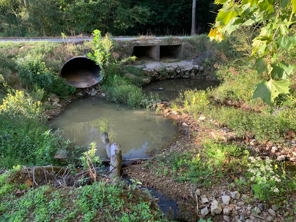
For example, the Nature Conservancy and the FWS recently worked with Etowah County to restore a section of Dry Creek, home to the rare rush darter, and replace a culvert pipe with a bridge spanning over the creek. Culverts, while they allow water to flow under a road, often restrict fish movement due to shallow water, debris or even being set too high above a creek’s water level.
“Everybody put skin in the game, everybody put money in the game,” Throneberry said of the Dry Creek project.

Total dam removal is an option favored by many environmental groups to restore the original flow of Alabama’s rivers and streams. Duncan said it can be “a form of multi-solving” several issues — endangered species, water quality, habitat loss, sea level rise, even protecting fisheries — with a single action.
The environmental benefits of dam removal are clear, but this has to be balanced against the many human uses of Alabama’s 2,200-plus dams, including hydroelectric power, drinking water reservoirs, recreation and boat navigation. It’s also expensive.
“I think from an ecological standpoint and reversing long decades of disruption in the system, dam removal would be the ultimate way to completely restore everything,” Lowry said. “… We recognize that those dams have been there for a long time. There are a lot of financial and community-based uses of the system as it is now, so looking at other options is important. Whatever can get the fish back upstream is going to be a huge step, is going to be a huge reconnection.”
Throneberry said dam removal was one of the alternatives originally under consideration for this project, but the Corps chose to cut it from the final list.
“The only thing that we know that will work 100% is taking the dams out. I was sad to see that taken off the table,” he said.


Removal can be the right choice when dams are abandoned or no longer serving their original purpose.
The Goodwin’s Mill Dam on Big Canoe Creek, in Springville, was removed in 2013 after having blocked that waterway for more than 130 years. In 2019, the U.S. Fish and Wildlife Service removed two Alabama dams: the Howle and Turner Dam on the Tallapoosa River, near Heflin, and an abandoned dam on the Sucarnoochee River, near Livingston.
Georgia Power has announced plans to stop the use of three of its dams on the Chattahoochee River, near Valley, with their eventual removal in 2023.
“I think from an ecological standpoint and reversing long decades of disruption in the system, dam removal would be the ultimate way to completely restore everything.”
Cindy Lowry, Alabama Rivers Alliance
Each river reconnection, whether replacing a single pipe or removing an entire dam, has the potential to save a species from disappearing from Alabama’s waterways forever.
“We are number one in aquatic biodiversity in North America. We’ve been given all these resources to harbor and protect,” Throneberry said. “… We just don’t want to sit back and watch it happen.”
Main article image by Tim Oberle, U.S. Army Corps of Engineers.